


 Research Article
Problems of Research of A Course of Rains
Received Date: June 09, 2024; Published Date: June 19, 2024
Abstract
In work questions of research of change in time of quantity of dropping out precipitation and their intensity are considered. This information is widely used in designing various economic objects (construction of water-carrying and sewer constructions, roads, etc.), forecasting of high waters and селей, speeds of flooding of territories, definitions of actions on struggle against a drought, etc. There are different approaches in decoding tapes of recorders of rains which unequally reflect the received supervision. Considering importance of such supervision, especially at changes of a climate, it is expedient to keep primary materials (tapes pluviographs) constantly or to digitize them. And the system of supervision is necessary for translating on devices with greater sensitivity changes of quantity of dropping out precipitation and digital record of results of measurements. It will give an opportunity not only to correct the random errors arising at processing of tapes pluviographs, but also in case of need will allow to translate numbers of supervision from one system of calculation in another. As rains with quantity of precipitation less than 2,5 mm bring the certain contribution to the general humidifying a reservoir (on a meteorological station Kiev is additional 23-68 mm of precipitation a year or 3-10 % from the annual sum of precipitation) on their meteorological stations should fix alongside with other rains for maintenance of any inquiries of a national economy.
Keywords: Pluviograph; rains; downpour; intensity precipitation; deciphering the pluviogram; national economy
Introduction
Course of rains this change in time of quantity of dropping out precipitation or their intensity. The information on a course of rains is used at planning construction of water-carrying and sewer constructions, forecasting of high waters and debris, speeds of flooding of territories, washout of a fertile layer of soils, damage of a vegetative cover and means of communication, definitions of actions on struggle against a drought etc. Rains of various intensity and duration differently influence water balance of territories and economic parameters of development of regions [1-4]. In aggregate all the phenomena accompanying loss of intensive downpours or long rains put substantial damages to the population and a facility of territories on which occur. It is the important physical -geographical feature of territories. Therefore, research of rains and downpours, including, is actual and does not lose the importance.
Pregoing research show, that the most exact conclusion of formulas of intensity of rains for concrete district can be made on the basis of the detailed analysis of records of recorders of rains of a local meteorological station for the period of not less than 12- 15 years, 30 years [5], etc. Eventually approaches to the analysis of the information on a course of rains varied, since features of use of this information varied. So, if earlier storm waters from territory of cities it was planned to dump as soon as possible in a hydrographic network now in many countries this water is considered as a resource and it aspire to use in territory of city [6] and this water for any period of time should be accumulated in drainage capacities. That - is, earlier the greater attention was given rains with a lot of precipitation and high intensity, and consideration of all spectrums of rains and with the greatest duration including now is required. Research debris also shows the necessity of research of all spectrums of rains. As not only intensive rains leading to formation debris, but also long precipitation of small intensity result to formation debris due to current of rocks on a surface of slopes. And, in this case have sat down appear more long, than at intensive precipitation [7].
Materials and Methods
Supervision over a course of rains at us in the country spent practically during 100 years periods by means of recorders of a rain: ombrographs, later pluviographs Gelman, P2 (record of change of a water level on the chart form) [8,9], modern electronic measuring instrument WОА-1М (the weight mechanism, weighing of water that acts, in a measuring instrument through 2 г that corresponds 0.1 mm of atmospheric precipitation). For this time the approach to the analysis of tapes of recorders of rains and selection of records of rains for the analysis changed. So, up to 1935 [10] storm rains were selected for the analysis according to Berg’s [11] norms where downpours meant rains during which for this or that time interval intensity of a rain did not decrease below sizes that is presented in Table 1. Later advantage in the publication is allocated to rains with quantity of precipitation more than 10 mm.
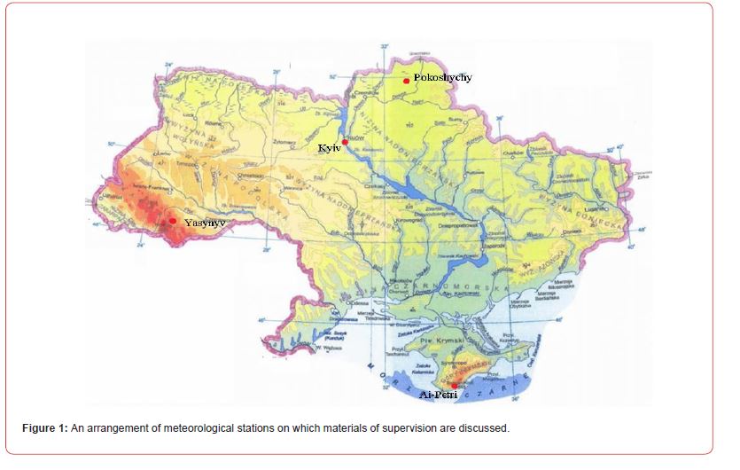
It is considered, what exactly precipitation in 10 mm and more form high waters on the rivers. Materials of decoding of tapes pluviographs with all fixed rains up to 1970 had resulted in Tables ТМ-14, later there began to place only rains with quantity of precipitation of 2.5 mm and more than. With 1984 materials of supervision by means of pluviographs on rains with quantity of precipitation of 2.5 mm also are more resulted in meteorological Tables ТМС - after stations and ТМП - on posts. Pluviographs parameters removed from tapes or on critical points (up to 1970), or through 10-minute intervals, and still association of intervals with a small difference of values of intensity of precipitation later is authorized. The analysis of features of studying of a course of rains in Ukraine is spent by us on an example of some supervision on 4 meteorological stations and including one water-balance station with a dense network pluviograph. The arrangement of meteorological stations is shown in Figure 1.
Table 1: E.J.Berga’s norms (1905) in definition of concept a downpour [10,11].
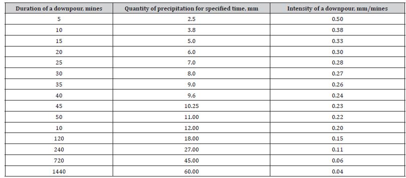
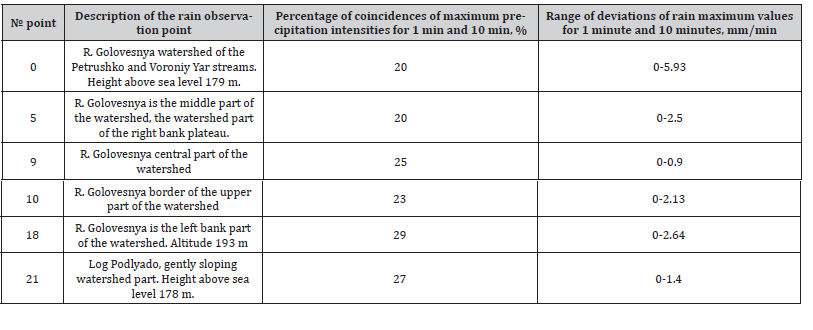
Table 1: Comparison of determination of maximum rainfall intensities for intervals of 1 minute and 10 minutes at the Pridesnyanskaya water-balance station for 1956-1985.
Results
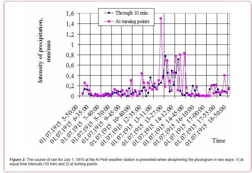
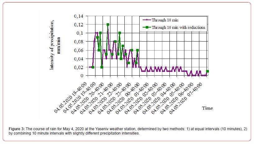
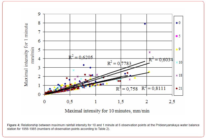
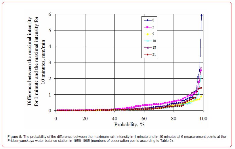
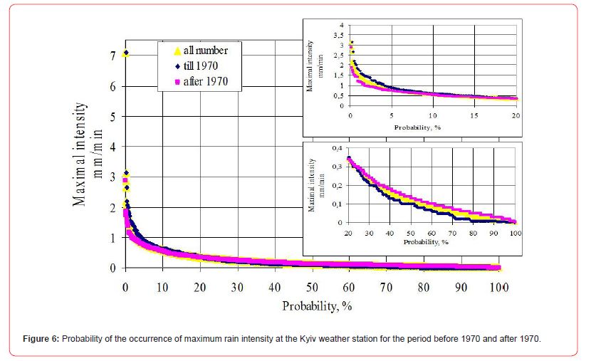
On meteorological station Ai-Petri materials with decoding tapes pluviographs both in the ways were kept on critical points and on 10-minute intervals (Figure 2). On Figure 2 it is visible, that at decoding on 10-minute intervals of time maxima of intensity of a rain appear reduced and time of loss of maximum quantities of precipitation is a little bit shifted. Decoding of tapes pluviographs through 10-minute intervals and through 10-minute intervals with association of intervals with poorly differing intensity precipitation also places shows displacement in time of peaks of quantity of precipitation (Figure 3). It also proves to be true results of processing of materials of supervision water - balance stations [12] (Table 2 and Figures 4&5). Besides for the long-term period smoothing maxima and increase in minima (Figure 6) is traced. The increase in minima can be connected by that since 1970 in TM-14 rains with quantity of precipitation less than have ceased to bring 2.5 mm. Comparison of the certain maxima of intensity of a rain for 1 minute and for 10 minutes resulted in materials of supervision on Pridesnyanskaya water –balance of station (meteorological station Pokoshychy) shows, that maxima of precipitation for 1 minute and for 10 minutes coincide only in 20-29 % cases on 6 items of supervision over a course of the rains located on one small reservoir R. Golovesnya the area 29.5 км2 (Table 2).
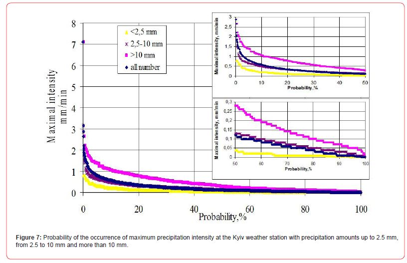
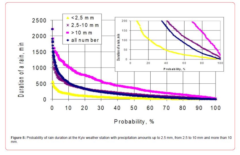
As mentioned above, the greatest negative consequences for the national economy are caused by rains, both with high intensity and long duration. With different amounts of precipitation, both cases occur with different probabilities (Figures 7&8). Most of the rainfall in the range from 2.5 to 10.0 mm in Ukraine is 50-70% [13] and in 10% of cases these rains have a maximum intensity of more than 0.5 mm/min. Rains of less than 2.5 mm also occur with a maximum intensity of 0.5 mm/min, but in 2-3% of cases (Figure 7). Rainfall with a precipitation amount of more than 10 mm and a maximum intensity of 0.5 mm/min occurs in 35% of cases. Rain duration of more than 10 hours with precipitation in the range of 2.5-10 mm occurs in 10% of cases, and with precipitation less than 2.5 mm less than 1% of cases, while with precipitation more than 10 mm such duration of precipitation occurs in 30% cases (Figure 8). Depending on the required reliability and capital construction of various economic facilities, either all rains or that part of them that meets these requirements should be used. However, weather stations must record the full range of rainfall to ensure that designers can use any range of rainfall to plan for any level of reliability and capital.
Conclusion
Since there is some deviation in the approaches to deciphering rain recorder tapes, given the importance of such observations, especially with observed climate changes and the specific availability of such materials to a wide range of researchers, it is advisable to preserve primary materials (pluviograph tapes) permanently or digitize them. And the observation system needs to be transferred to instruments with greater sensitivity to changes in the amount of precipitation and digital recording of measurement results. This will provide the opportunity not only to correct random errors that arise during the processing of pluviograph tapes, but also, if necessary, will allow the transfer of observation series from one calculation system to another.
Since rains with a precipitation amount of less than 2.5 mm make a certain contribution to the overall moistening of the catchment area (on a meteorological station Kyiv is additional 23- 68 mm a year or 3-10 % from the annual sum of precipitation) and contribute to the occurrence of situations with flooding of territories or the activation of erosion and mudflow processes, they should be recorded at weather stations along with other rains to meet any needs of the national economy. Some other authors also believe that the time intervals for which maximum precipitation intensities are determined do not have to be fixed; their search in pluviograms should be carried out in a flexible way, that is, identifying periods with any time interval where effective precipitation was observed [14]. To guarantee the reliability of models of precipitation characteristics according to WMO data, sets of precipitation records must have a sufficiently long measurement period and high resolution of precipitation recording, on the order of a single minute [15,16]. All this will provide the opportunity to correctly set the characteristics of rain to solve any economic problems.
Funding
The author declares that no funds, grants, or other support were received during the preparation of this manuscript.
Author Contributions
All the work presented in this paper was conducted by the author.
Conflicts of Interest
The author declares no conflicts of interest regarding the publication of this paper.
References
- Soo See Chai, Wei Keat Wong, Kok Luong Goh (2017) Rainfall Classification for Flood Prediction Using Meteorology Data of Kuching, Sarawak, Malaysia: Backpropagation vs Radial Basis Function Neural Network. International Journal of Environmental Science and Development 8(5): 385-388.
- Bates BC, Kundzewicz ZW, Wu S, Palutikof JP (2008) Climate Change and Water. Technical Paper of the Intergovernmental Panel on Climate Change, IPCC Secretariat, Geneva. PP. 210.
- Молоков МВ (1964) Дождевая канализация площадок промышленных предприятий- Л.-М:Изд. лит. по строительству
- (1985) Технические указания по проектированию и строительству дождевой канализации. / Хуторцов Г.М., Молоков М.В., Тюрин М.Т., Львов Л.Н., Воронин В.А. М:Стройиздат
- Metodyka opracowania Polskiego Atlasu Natężeń Deszczów (PANDa). // Pod red. Pawła Licznara i Janusza Zaleskiego. Warszawa 139s.
- PN-EN (2017) Drain and sewer systems outside buildings – Sewer system management. Zewnętrzne ystemy odwadniające i kanalizacyjne – Zarządzanie systemem kanalizacyjnym, PKN, Warszawa. PP. 96.
- Боярский И.Я., Семивод Г.Н (1979) Количественные показатели движения селей оплывинно-оползневого генезиса (на примере ручья Малый Мукулан). // В кн.: Сели в горных районах СССР.-Изд Московск универс. PP. 12-24.
- КД (2011) Настанова гідрометеорологічним станціям і постам. Вип.3. Частина 1. Метеорологічні спостереження на станціях. Київ: Державна гідрометеорологічна служба. PP. 286.
- Наставление гидрометеорологическим станциям и постам. Вып (1969) Метеорологические наблюдения на станциях. Ч.2. Обработка материалов метеорологических наблюдений. Отв. ред. Т.А.Огнева. - Л.: Гидромет. издат. 116.
- Водный кадастр Союза ССР (1940) Ливни на территории СССР. Под ред. З.П.Богомазовой. Л-М: Гидромет. издательство. PP. 431.
- Берг Э.Ю (1924) Данные о наиболее выдающихся ливневых дождях разной продолжительности за десятилетие 1903-1912 гг. на территории б. Европейской России. Географический сборник.
- (2017) Многолетние характеристики гидрометеорологического режима малых водосборов Украины (Материалы наблюдений Придеснянской В, Богуславской ПЭГБ, Велико-Анадольской В). Под ред. Ю.В.Шейкина, Н.Д.Ещенко, И.И.Шейкиной. PP. 612.
- Budnik SV (2023) Relationship and Variability of Atmospheric Precipitation Characteristics in the North-West of Ukraine. Journal of Atmospheric Science Research 6(3): 30-40.
- Kotowski A, Kaźmierczak B, Dancewicz A (2010) Modelowanie opadów do wymiarowania kanalizacji. Studia z Zakresu Inżynierii, Warszawa PP. 128.
- WMO (2012) Guide to Meteorological Instruments and Methods of Observation. WMO-No. 8, World Meteorological Organization, Geneva. pp. 716.
- World Meteorological Organization (2018) Guide to Instruments and Methods of Observation. World Meteorological Organization: Geneva, Switzerland. pp. 548.
-

This work is licensed under a Creative Commons Attribution-NonCommercial 4.0 International License.